Sunday, October 13, 2013

Sea of Mountains – 3 Bonds in a Day 10/14/13


This was a monster hike and if I told you I thought it would be a piece of hike, I was lying.  I left West Boylston at about 4:00 and met Kyle at the Hudson park and ride at 4:30.  I’ve never seen 495 so quiet on this ride up.  I think it was somewhere before Concord, NH that we saw a shooting star which was perfect because I wished for a safe and rewarding hike so I could get back to my family unscathed. 

We arrived at the Lincoln Woods parking lot at about 7:00 after stopping at White Mountain Bagel Company for breakfast sandwiches.  Because of the government shutdown, there was a sign on the welcome board that no parking fee was required.  There was a heavy overcast, but the weather report called for clearing skies around 11:00.  There were quite a few vehicles already in the lot and our boots hit a leafy and flat Lincoln Woods Trail at 7:11 and reached the Bondcliff Trail at 8:30.

Franconia Brook footbridge
The first couple of miles of the Bondcliff trail was on an old railroad bed, but as we started gaining elevation we found ourselves in the clouds.  There were lots of leaves covering some smooth rocks on the trail which made for an occasional foot slip and one section of the trail was a little muddy, but overall the trail was in great shape.  We ran into about 7 people heading down the trail and every one of them said we have sunshine and incredible views ahead of us.  If we ran into another 20 people and they told us the same thing, I wouldn't be sick of it. We also saw a couple of campsites abutting the trail along the way.

Railroad track at the beginning of Bondcliff Trail
Leafy Bondcliff Trail with some last bits of foliage
Misty Mountain Hop
Kyle in the clouds with his iPhone
When we reached a short escarpment on the trail, we were finally out of the clouds and the view over to the Franconia Ridge was awesome.  We were up above the clouds for a while on the cliffs and stopped to enjoy them and take the obligatory cliff photo shot.

Up and at'em over the Bondcliff escarpment
First view of Franconia Ridge with Owls Head poking up
Bondcliffs in the clouds
Rainbow halo
Hikers on the cliffs
Kyle on the cliff

Me on the cliff
As we headed over to Mt Bond, we went back into the clouds.  It was a surreal feeling hiking in the thick "fog" and following the cairns to stay on the trail.  What a surreal feeling it was hiking in the cloud and relying on the cairns to figure out where the path was leading us.  We reached Mt. Bond at 11:45 and stopped for another break and more photos.

In the clouds on the Bondcliff Trail headed to Mt. Bond
There's the cairn
Bondcliffs from Mt. Bond
West Bond from Mt. Bond with the Franconia Ridge in the background
Presidential Range from Mt. Bond
The spur trail over to West Bond had a significant drop and gain in elevation and we reached the peak at 12:30.  We took another break and enjoyed the views.  At this point the cliffs were being completely submerged in the clouds.

Mt. Bond from West Bond
Bondcliff being swallowed by the clouds
Couldn't get enough of the Franconia Ridge (Those clouds above didn't move all day!)
Carrigain and Osceola from West Bond...  I think...
Twins from West Bond
We headed back to Mt. Bond and I took a break to swap out my socks and I put my camera away in preparation of the hike down.

Looking back at West Bond and Franconia Ridge
Liberty and Flume with Moosilauke in the back from Mt. Bond
Looking north towards the Twins and Mt. Guyot
We really didn't take another break until we reached a small watering hole at Black Brook on Bondcilff Trail.  I busted out the old PUR filter and grabbed a couple of liters.  We trudged on in what felt at times like a drunken stupor until our next break at the footbridge over the Pemi.  We reached our car at about 5:30 after passing several groups of people who seemed to be predominantly from India...

Stats:
Lincoln Woods Trail: 2.9 miles
Bondcliff Trail: 7.9 miles
West Bond Spur: 1.0 miles
Bondcliff Trail: 7.9 miles
Lincoln Woods Trail: 2.9 miles
Total Miles: 22.6
Approximate Time: 10:15
Total Elevation Gain: 4,800 feet

Saturday, September 28, 2013

Welch-Dickey Loop 9/28/13

 After finishing up the Hancocks so early we didn't want to waste any of a gorgeous day and started heading south to hike either Mt. Tecumseh or the Mt. Welch-Mt. Dickey Loop.  We stopped at a sub shop just off 93 on route 49 to get something to eat and decide which hike we would do.  Kyle and I both got a cheeseburger which was dry and probably consisted of 1/2 hamburg and 1/2 soy beans.  While suffering through the burger we decided on  the Mt. Welch-Mt. Dickey Loop.

To reach the trail we followed route 49 East for about 5.5 miles to Upper Mad River Road and then took a right onto Orris which quickly led us to the parking lot for the trail head which was packed.  Because it was later in the afternoon, we managed to find a spot in the lot.  I personally took this hike lightly because after doing two 4,000 footers, I figured this hike would be like a quick hike on Wachusett.  But, much like Tecumseh earlier this year the ascent to the mountain was a moderately steep grade mostly on granite slab for the first couple of miles and not as easy as anticipated.  When we reached the first vista point the views were great overlooking Mt. Tripyramid to the East and the Sandwich Range to the South.  Welch Mountain stuck out behind us like a sore thumb.

A view towards Mt. Welch from the first scenic outcrop
The Easterly view towards Mt. Tripyramid
Southerly view towards Sandwich Range
As we headed up towards Welch Mountain we climbed more flat slab and started encountering some large groups of people.  In between the summits we hit one of the rare wooded areas on the hike and before that there were a couple more groups of people just hanging out and enjoying the great day.  We quickly went up and over Mt. Dickey and took it slow the rest of the way going downhill on more flat rock slab.  It was getting tough on the knees and my dogs were barking really loud on the descent.  There were still plenty of views which we stopped a few times to take in.  It was a good finale to the day and when we got back to the parking lot Kyle busted out a foam roller and a massaging rolling pin which felt good and bad at the same time when I used it.

Kyle looking towards Mt. Dickey
Looking back at Mt. Welch
A view North towards Kinsman Ridge
Zoomed view North to Mts. Flume, Liberty, Lincoln and Lafayette
Looking North to the steep dropoff from Cannon into the Cannonballs
Knee busting ledge on the descent from Mt. Dickey


Stats:
Welch Dickey Loop Trail: 4.4 miles
Elevation Gain:  1,060 feet
Time: Approximately 2.5 hours
Book Time: 3 hours 5 minutes


Slaying the Beast - North and South Hancock 9/28/13

After an unsuccessful trip to complete the North and South Hancock loop earlier this year in March, I needed to get back out to North and South Hancock to "Conquer the beast".

Kyle and I left the Berlin, MA park and ride at 5:00 and arrived at the parking lot at the hairpin turn on the Kancamangus just before 7:30.  The temperature was 38 degrees.  At the trailhead I saw Sandi who I had carpooled with on a Random Group of Hikers meetup to Osceola.  After taking a minute to say hi, our boots hit the flat Hancock Notch trail at 7:40.  The trail was pretty very easy going with very little roots and rocks and was as a great warm up in the cool temps.  One stream crossing at 0.6 (according to the book) required some quick and nimble footing on some pointy boulders.

Kyle heading down the Hancock Notch Trail
Rock stairs on the Hancock Notch Trail
We soon reached the familiar Cedar Brook Trail Junction sign.  This was the first indicator of how much snow there actually was when we came out here back in March.  At one of the brook crossings further down the trail there was a herd path that cut to the right and we clearly remembered that this is where our last trip went awry when we followed those two bush whackers.  We knew that we had to cross the river up an embankment and under a tree to stay on the trail.  For about 200 feet the trail seemed to follow a floodplain for when the brook is overflowing and this was evident by the giant puddles and mud.  We were only on the trail for 0.7 miles and were soon off it when we reached another very familiar landmark at junction of the Hancock Loop trail.

Kyle trudging through the mud on the Cedar Brook Trail.
 March 2013 and September 2013, what a difference 6 months makes.
The Hancock Loop trail was considerably drier and the river crossings were easily managed with some well placed feet.  Heading to the actual loop portion of the trail, we senselessly discussed the possibility of attempting to summit North Hancock via the Arrow Slide.   On the ascent to North Hancock, I kept my eyes peeled for any signs of a bush wack to the east of the trail.  About 1/3 of the way up the the steep incline to the peak were a line of trees which had clearly been cut down heading in the easterly direction.  I didn't get in there to explore because we had already wrote off the slide ascent, but it was most likely the way to the slide.  The ascent up the trail was quick as compared to our winter misadventure.  Once at the summit we headed to the outlook where the views to the south were very rewarding.  We were joined at the summit by three other hikers.

Arrow Slide from North Kinsman trail.
More stone steps heading up North Hancock trail.

Looking down the Hancock Notch trail.
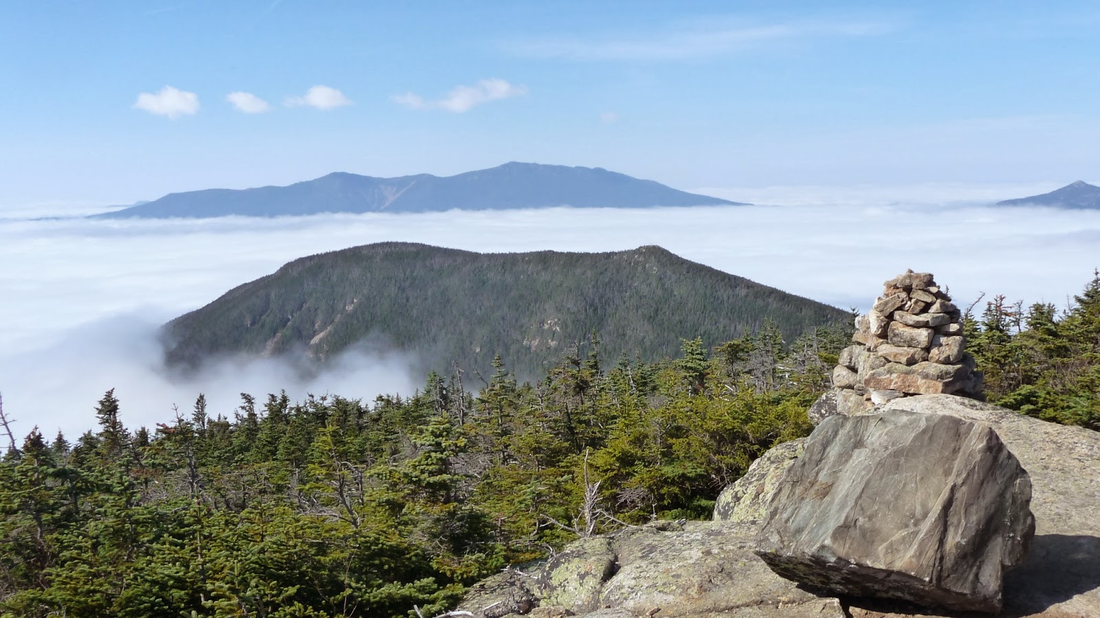
Scar Ridge from North Hancock overlook
Mt. Osceola from North Hancock overlook
After taking a break for about 15 minutes, we hit the trail again headed for South Hancock.  After a turn on a trail there sat a Spruce Grouse.  He was sitting right in the middle of the trail and when we closed in on him he flew up in a tree and just sat there above us.  It's was so cool when you can get so close to an animal without it flying away in fear.  We continued on and surprisingly reached the South Hancock summit in a less than an hour.  It seemed that all the hikers who were on the trails that day converged on the summit.  The outlook gave us great views to the East.

Spruce Grouse on the trail
Grouse in the tree
Pemigewasset Wilderness with the everpresent Mt. Chocura in the background
The trail down South Hancock was steep and rocky with some spots of scree.  There were views of the Arrow Slide and the Franconia Ridge from the South Hancock trail.

A view of the Arrow Slide from the South Hancock trail.
Mt. Lincoln and Lafayette from the South Hancock trail.
The way back to the Kancamangus was smooth going and we saw a lot of hikers heading towards the peaks.  And as we were getting closer to the Kanc we saw more and more out of place hikers.  One guy wreaked of cologne and I think his wife even may have been wearing heals.  I didn't know what to make of it until we got to the parking lot at about 1:00.  The place was packed with people hanging out.  From bikers to cotton heads but not many hikers.  One couple we saw on top of South Hancock couldn't get out of there fast enough and were headed to Moosilauke.  At one point there were a bunch of Need for Speed type cars that reving up their engines around the hair pin turn.  It was so loud and was a real welcome back to fucking reality.  Regardless of the scene at the parking lot, this was a very rewarding hike because this time we conquered what turned out to be not so intimidating mountain after all.

Stats/ route:
Hancock Notch trail:  1.8 miles
Cedar Brook trail:  0.7 miles
Hancock Loop trail:  4.8 miles
Cedar Brook trail:  0.7 miles
Hancock Notch trail:  1.8 miles
Total mileage:  9.8 miles
Total Elevation gain: 2,650
Approximate time including breaks: 5 hours 20 minutes

Saturday, August 24, 2013

Flume, Liberty, Lincoln & Lafayette 8/24/13

This was to be the biggest hike of the year for me over 15 miles and the first 5,000 foot peak and three 4,000 foot "48 official" peaks.  We left the Hudson park and ride and 4:00 and reached the Falling Waters parking lot at 6:30.  The temperature in my car read 42 degrees and when we got out of the car we found out it was pretty accurate.  Luckily I brought my winter hat and wore a cotton layer on the way up.  While getting out gear ready, I dropped my camera on the pavement which rendered it useless and Kyle's Osprey hydration bladder cracked open right at the handle.  Luckily Kyle had his iPhone to take plenty of pictures for this blog and had a gallon of water to carry.  Once we got everything in order, we started on the bike path to Liberty Springs trail at 6:45.  We had no luck finding the ascending Basin Bushwack I asked about on a HikeNH forum, but it was clearly visible at a big corner on Liberty Springs.  We took the Flume Slide Trail off of Liberty Springs and it felt like it took forever to get to the slide portion of the trail.  The trail couldn't have been any drier and the first views of the day looking back from the trail was awesome.  But I felt that the slide was steeper than the Tripyramid North Slide at times and stopping to look back gave me a little vertigo.


Mt. Flume was awesome.  We had to follow huge rock outcrops to the actual peak of the mountain.  On the top of Flume, we met an extraordinary couple.  Mike was a mountaineer who organized hikes to Kilamajaro, Everest, Macho Picchu and the money generated from those hikes went to his wife Lilas orphanage.  Their website is http://www.flyingkites.org.  The hike to Liberty looked to be an imposing up and down but it definitely was easier and quicker than it looked.  On the top of Liberty there was a large group of younger hikers with hand tools, hard hats and safety glasses who were heading to do some trail maintenance somewhere.


The ridge trail between Liberty and Lincoln was very quiet and Kyle and I split up for a while. It was so quiet if felt like I was wearing earmuffs.  I found a piece of black "fur" on a portion of the trail and thought it was bear fur and held on to it to show Kayla when I got home.  It's the fur from Mordu!  A few minutes later on the trail Kyle and I stopped to check out some fresh bear scat.  The bear scar, chunk of fur and deafness of the trail made us a little uneasy and actually slowed down our pace as we employed our bear defense techniques.  As I clapped and Kyle yelled "Yo Bear!" the silence of that portion of the trail quickly changed when we reached Mt. Lincoln.  There were so many people on top of the mountain, but they were all in the background because the views were awesome.  Some of the people that went up the mountain seemed so out of place and probably were dreading the way down.


We must have thought Little Haystack was Mt. Lafayette because when we finally got to the top of Little Haystack and looked to the north, the trail to Lafayette gave us a big reality slap.   There was one last climb left to the top of Lafayette but that was only before another big drop off.  We hung out on top of Lafayette for a while and Kyle cooked up some inedible Mountain House Jerk Chicken.
The way down Lafayette on the Old Bridle Path was pretty fast going unless someone was in our way. Usually when someone was in our way, it seemed that they didn't want to move out of the way.  According to a couple of hikers, I almost got taken out by some girl that was running down the mountain.  All I heard the scree scraping under her shoes behind me.  It was a great day despite my new Vasques (~45 miles) ripping open at the toe as we finished at 3:30.  Approximately 15 miles in 8:45 minutes including several breaks on the peaks.  Great leg and cardio workout but it took a toll on my back which kept me from going back on the peaks the next week.